So the first chase day will be be May 25, 2019, and I plan to be in place for that. The 500 mb height/wind, 700 mb height/temperature, and surface dew point field given above are from the 12 UTC run of the NAM on 5/22/19, forecast for Saturday afternoon 5/25/19.
These show implied favorable wind shear from the surface to 6 km (500 mb winds around 40 knots are greater for storm ventilation and mid level rotation.  The surface dew point field shows a dry line punch into north-central Kansas that afternoon. ml CAPE values (not shown) of 3000-4000 J/kg are substantial.
  The problem might be the cap…as implied by the 700 mb temperature field shown. The deep yellow colors extend into KS, with just north-central KS at the edge.
This forecast sounding is for a spot between Salina and Hill City. All the parameters are great, but you can see the remains of the capping inversion present at 0000 UTC is awful close the parcel ascent curve. This suggests initiation may be an issue.
In any case, the parameters that measure the chances of the supercell cascade proceeding to “conclusion” are suggested to be in place over that area Saturday
afternoon.  This shows one such parameter, the Supercell Composite Parameter. There’s definitely a signal in this preliminary target area.
Beyond Saturday, the GEFS model continues the prospects. In fact, it has been suggesting what meteorologists refer to as a “synoptically evident” pattern towards Monday, May 27.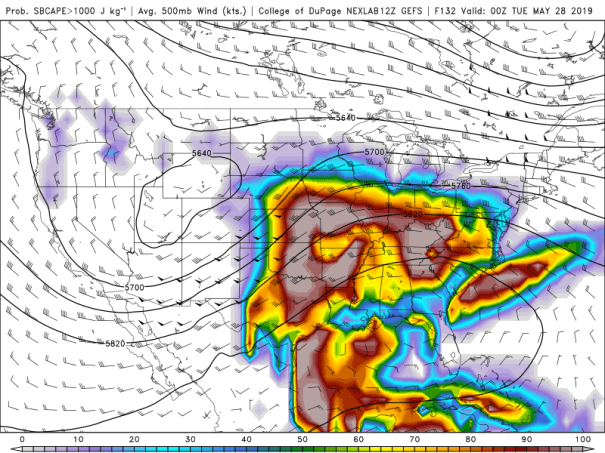
This shows a very prototypical pattern for severe weather in the Great Plains. The 500 mb heights and winds suggest a strong southwesterly jet over the area from Oklahoma northward to southern Nebraska. And this will overspread ample CAPE (the colors show the chances that CAPE values will exceed 1000 J/kg.
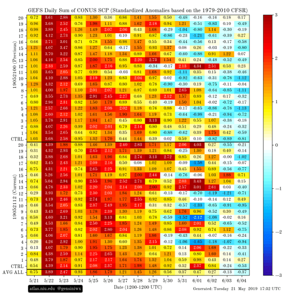
The other set of tea leaves posted here include the Extended Range Tornado Activity Forecasts (ERTAF) from the Victor Genuine group. The red and orange tiles at the bottom shows the average risk for SCP values favoring tornadoes based upon the average of all 20 ensemble members from the GEFS. Based upon this, there is confirmation of chasable patterns on the 25 through the 29th or 30th.