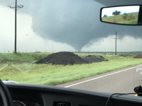
Metropolitan State Crew Witnesses Several Tornadoes Near Waynoka, OK
This cell phone capture is by Scott Landolt. Other photography by Sam Ng and Cameron Redwine coming.
First Storm Rapidly Becomes a Tornado Producer

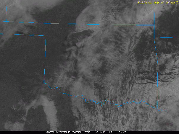
Convective initiation has happened in the area along either side of the Red River west of Wichita Falls. The first storm rapidly became a supercell, with a confirmed tornado.
Discussion
Ingredients are going to be phased this afternoon for an outbreak of high-end severe weather in the southern Great Plains. The morning surface map is reminiscent to me of several in which the triple-point area has high enough dew points on both sides of the synoptic-scale boundary to mitigate any problems with CIN. In fact, there may be too little CIN, and too many storms with outflows interfering with one another.

However, the convection-allowing-models are suggesting the an early round of storms will not disrupt the low level moisture and shear fields, although there will be boundaries around to complicate things. So my attention is drawn to the eventual location of the triple-point this morning, which will slowly end up 100 miles or so further northeast.
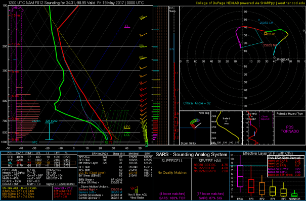
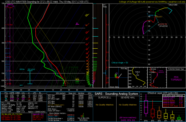
There, in the strongly backed surface flow, the hodograph loops are forecast to be enormous, eventually. But with some suggestions that the first storms will be in a shear environment that will have them entraining precipitation into their updraft areas initially (see 2100 UTC sounding/hodograph for a point between Woodward and P28) in a setting with enormous CAPE. But by 0000 UTC that hodograph weakness does not appear to be an issue (see 0000 UTC sounding/hodograph not at the same location but a bit further southeast).

My initial target would be sort of in the middle of that box, about halfway between Woodward and Medicine Lodge. It will be difficult not to give into the impulse of chasing the first storms that popup, because they will be supercells. They will also be fast moving, taking observers further away from the eventual target (I think).
I should point out that some interesting set of ingredients also along Red River area around 0000 UTC but with, it looks like in the forecast soundings, too much CIN. But if a storm develops there…boom, with lots of low level shear too. This forecast sounding is for a spot between Wichita Falls and Altus at 7PM CDT.