What We Saw
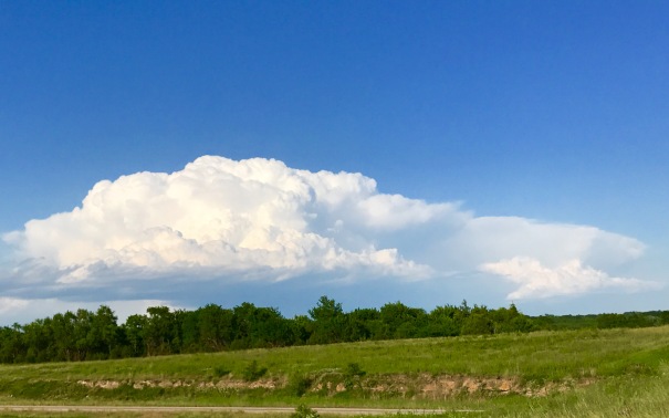
We held up in Salina and went a little further east, to catch developing storms moving towards Lawrence KS. However, a cell rapidly developed southwest of Russel, KS, about 60 miles to our west. It immediately became tornado warned.
So we decided to drive back towards it since it was moving slowly north east. That decision proved a very very good one.

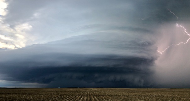
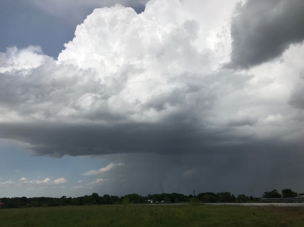
As we drew closer to intercepting the rain free base, a bulbous lowering developed. And then a very large tornado, between a wedge and a stove pipe, with a satellite tornado on its north side.

When we were within 5 miles or so, the view opened up to a scene of utter beauty and atmospheric violence. (Picture used with permission by Cameron Redwine)

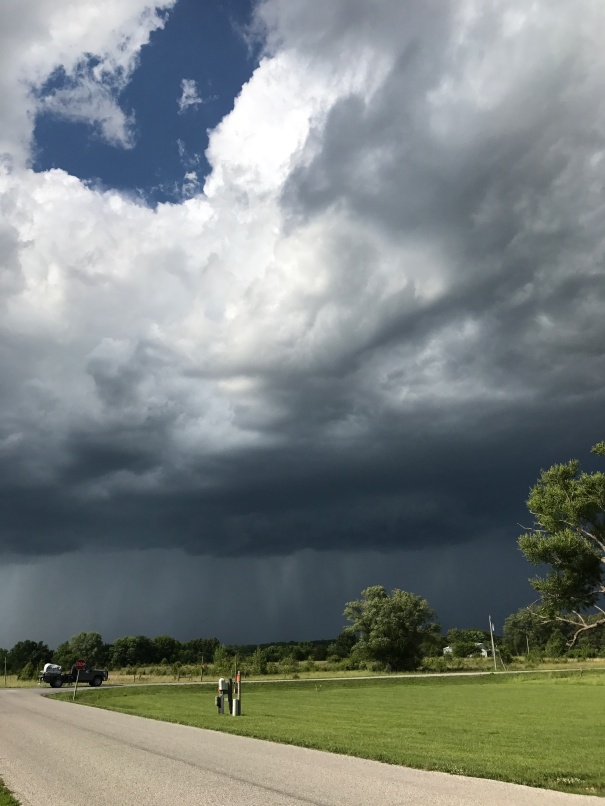
And then we were treated to quite a spectacle.

After 10 minutes or so the tornado shrunk to an elephant trunk with another funnel off to the west (not shown in this picture).
Then a third tornado formed to the north of the original updraft area.

The original tornado continue to shrink to the “rope” stage.


We attempted to stay with the storm, stair stepping across north-central KS. And we saw one more tornado in the distance. But we were never really able to view the storm again while it was actively Tornadic.
So we called it a chase. And on our way back, we were able to see the back sides of the big storms that caused so much havoc in our original target area.


This view of the supercells to the east shows the backsheared anvil with “knuckles” of one east southeast of Salina. A great view as we called it “a chase”.
___________________________________________
Targeting Decision
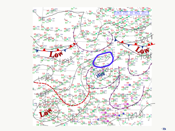
The boundary left over from the previous evening’s thunderstorms lay over northeastern KS. That cold air had joined with the cold air north of the synoptic scale boundary. This left a beckoning source of low level vorticity in northeastern KS.

This area of high dew points was associated with rich CAPE and little CIN expected in the afternoon ahead of a surface trough between the moisture advection area and the Dry Line, which was too far west to be a player in Kansas.

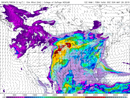
The continued presence of a southwesterly flow with embedded disturbances also lay over central and eastern KS. The juxtaposition of favorable deep layer shear, CAPE, and low level shear is quantified by the Supercell Composite Parameter. This does not mean that supercells will form in the highest valued areas, but that if thunderstorms do form they have all the ingredients for supercells.
The convection allowing models showed that during the afternoon thunderstorms would begin formig in south-central KS and then move northward towards the boundary, where the low level shear was the most favorable. So we targeted the area in the box drawn on the surface plot above. But note the area of high SCP curling around the northside of the low,
The forecast sounding for the area just east of Salina shown below describes a thermodynamic and shear environment favorable for powerful supercells and tornadoes.


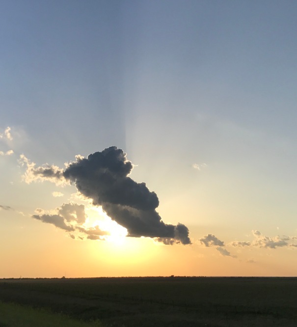
 The storm became a stacked wedding cake, with beautiful lightning on its northeast flank.


 The initial storm we tracked in se Colorado looked briefly good. But we left that behind to target a storm southwest of Lamar, Colorado. It had intermittent wall clouds and reports of tornadoes. We did not see any tornadoes…but in these two pictures apparently observers near by the features saw them. The storm was tornado warned.

 The radar imagery shows the development of the hook on the storm near Lamar. The radar site was Pueblo, CO, which was to the left of the image. You will note the couplet that developed on the south side of the storm (green next to red on the velocity image) and the associated tornado warming (red quadrilateral).
 When we got back to Garden City, the storms we had been chasing congealed into a squall line. The lightning would not cooperate when I took this short video.


 The surface dew point field shows a dry line punch into north-central Kansas that afternoon. ml CAPE values (not shown) of 3000-4000 J/kg are substantial.
 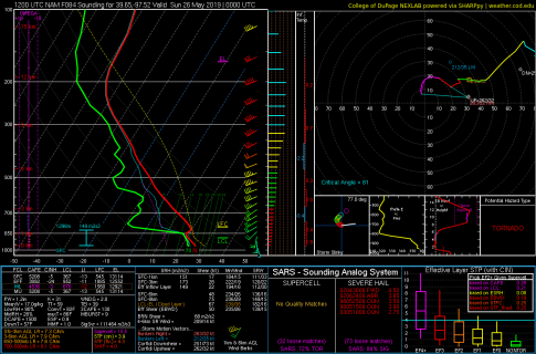 The problem might be the cap…as implied by the 700 mb temperature field shown. The deep yellow colors extend into KS, with just north-central KS at the edge.
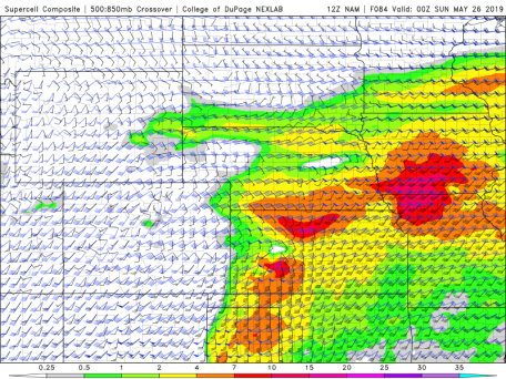 This shows one such parameter, the Supercell Composite Parameter. There’s definitely a signal in this preliminary target area.


 .
.


